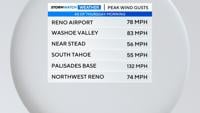
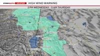
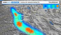
We’ll see an increasing chance for afternoon and evening showers and thunderstorms through the end of the work week.
Thunderstorms activity will be isolated in nature on Wednesday… with less than a 20% chance here in the Reno and Carson City area. And our temperatures will remain warm in the mid-70s and ten degrees above average for this time of the year.
The first in a series of upper level lows will work it’s way towards the California coast through Friday, bringing with it increasing chances for showers and thunderstorms. It looks like Friday will be the most active afternoon here in the area.
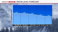
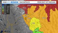
A second low swings out of the Gulf of Alaska for the weekend… this will keep us cool and unsettled. And we’ll likely see some accumulating snow in the higher reaches of the mountains and especially along the Sierra crest.
Highs Sunday will tumble into the mid-50s.