Boating could be dangerous this weekend as wind speeds top 30mph and chop reaches 1-4 feet on our area lakes. While it will be windy on Saturday, wind speeds will be the strongest on Sunday. This is not the worst wind event we’ve ever seen, but wind speeds will be strong enough to blow around some dust, toss around picnic napkins, and create some chop on area waterways. Fire danger will be increased as well.
Lake Wind Advisories are up for much of Northern Nevada with High Wind Watches up for Southern Nevada. Wind Advisories are also up for parts of central Nevada, including Mineral and Lyon Counties. The Wind Advisory goes from 11am to 11pm on Sunday where wind gusts could reach 45mph.

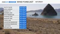

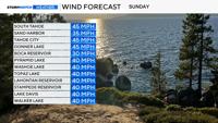
Pyramid Lake could see wind gusts up to 40mph with sustained winds ranging between 20-30mph. Wave heights will range between 1-4 feet and will be worse on Sunday than Saturday. Lake Tahoe is similar with wave heights forecasted be slightly lower than Pyramid.
Lake Wind Advisories are also up for area lakes in Northeast California this weekend. Wind gusts will be around 40mph, especially on Sunday, but it will be windy on Saturday as well.
Kayaks, paddle boards, and other small craft could capsize. Lake Tahoe is very cold right now with a temperature of just below 54 degrees Friday morning.

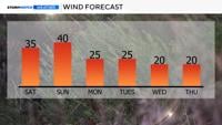
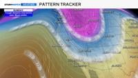
An area of low pressure and associated cold front arrives on Saturday dropping temperatures into the 70’s. A second and stronger trough with a cold front arrives on Sunday. Highs on Sunday will only be in the low 60’s in Reno. The wind will make it feel chilly.