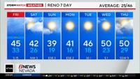


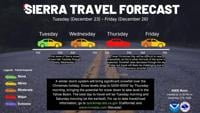


UPDATE: Rain in Reno, snow in the Sierra keep slick roads, closures, and travel impacts across Nevada and California
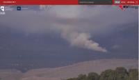
Snow continues across the Sierra and western Nevada on Friday morning, with rain in Reno and the surrounding valleys.
Drivers should expect slick roads, chain controls, closures, and travel delays as the winter storm impacts northern California and western Nevada into this afternoon.
The National Weather Service in Reno reports:
Winter Weather Advisory for Reno, Carson, and Minden remained in effect until 10 a.m. on Friday
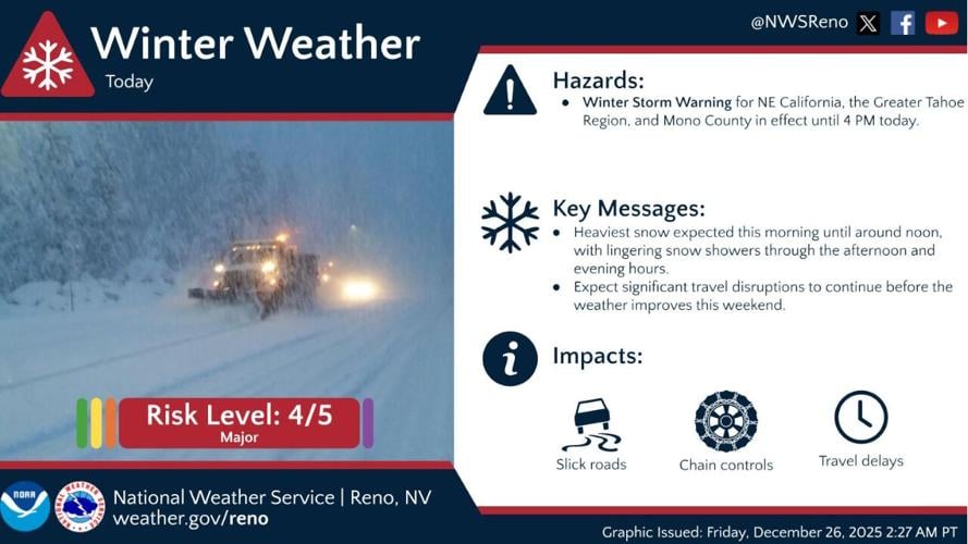
Winter Storm Warning for the Sierra, northeast California, Greater Tahoe region, and Mono County has been extended until 4 p.m. on Friday
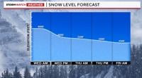
Heaviest snowfall is expected this morning, 5 a.m. to 9 a.m. in Reno and through noon in the Sierra, with lingering snow showers into the afternoon and evening. Significant travel disruptions are expected before conditions improve this weekend.
Chain controls and road conditions
Chain controls remain in effect on key highways:
I-80: R-2 in both directions from the Nevada state line to Nyack
SR-267: R-2 from Truckee to Kings Beach
SR-89: R-2 from Truckee to Tahoe City
SR-28: R-2 from Tahoe City to Kings Beach
Trucks: At maximum restrictions
Additional chain requirements remain in effect on:
U.S. 50 between Fred’s Place near Kyburz and Meyers
SR-207 (Kingsbury Grade Road)
In Mono County, U.S. 395 is now a snow road, with drivers advised to expect delays near Wilson Butte due to avalanche control operations. Motorists are reminded not to crowd snowplows and to take their time reaching destinations.
Caltrans notes that QuickMap is the most reliable source for current road conditions, as other mapping apps may not reflect real-time updates: https://quickmap.dot.ca.gov.
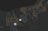
Highway closures
Mount Rose Highway (SR 431) remains closed between Mt. Rose Ski Tahoe and Fairview Boulevard in Incline Village while crews continue snow and ice removal
State Route 89 through Emerald Bay remains closed due to unstable snow conditions
High-profile vehicles, trailers, and permit loads are advised to avoid mountain passes during ongoing snowfall and avalanche control operations.
High wind impacts
High wind warnings are in effect across exposed mountain areas and western Nevada. Motorists may encounter strong crosswinds, particularly on ridges and open stretches, which can affect high-profile vehicles and create blowing snow hazards.
Avalanche and flood concerns
The Sierra Avalanche Center continues to warn of unstable snow conditions in the Greater Lake Tahoe backcountry. Recent snowfall and wind-loading could trigger avalanches; backcountry travel in avalanche terrain is not recommended.
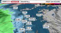
In Lassen County, the Susan River at Susanville continues to be monitored for potential flooding. While conditions are improving, residents are urged to avoid flooded roadways and low-lying areas. Sandbags remain available through the Susanville Fire Department.
Winter driving tips
Authorities continue to stress safe winter driving practices:
Vehicle preparation
Tires properly inflated; winter tires recommended
Battery, fluids, and windshield wipers checked
Fuel tank at least half full
On the road
Slow down, increase following distance
Avoid sudden braking or turns
Be alert for ice, snow, and shaded areas
Emergency preparedness
Warm clothing, blankets, food, water, traction materials, and jumper cables
Visibility and pedestrians
Clear snow and ice from windows, mirrors, headlights, and the roof
Watch for pedestrians walking in roadways where sidewalks are unplowed
Bottom line for travelers
Travel across the Sierra, northern California, and western Nevada remains hazardous on Friday. Motorists are urged to check road conditions frequently, carry chains when required, allow extra travel time, and stay alert for rapidly changing conditions.
For updates:
Nevada drivers: Nevada 511 (website or app)
California drivers: Caltrans QuickMap (https://quickmap.dot.ca.gov), Highway Advisory Radio (530 AM, 1610 AM, 1670 AM), or 1-800-427-7623
Weather updates: National Weather Service Reno or the 2News app