

Visibility will be poor along I-580 towards Washoe Valley and Carson City on Thursday because of moderate to heavy snow. Travel is not advised and expect delays.
Be prepared for more shoveling today, especially in areas to the northeast of Tahoe because of lake enhanced snow. Roads will be slick and snow covered through at least the lunchtime area across Reno, Carson City, and Sparks, but conditions will improve for some by the afternoon. The snow becomes more showery and scattered as the day goes, allowing snow totals to vary greatly.

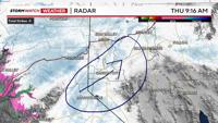
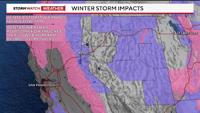
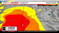
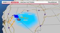
This image was taken around 9 AM Thursday morning, and paints the image of what the pattern will be like throughout the day because of lake enhanced snow and flow wrapping around the backside of the low. This creates narrow bands of heavier snow over Mt. Rose Highway and up through Washoe Valley and even Virginia City.
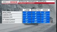
In general, snow totals will range from 1-4 inches in the lower elevations to up to six inches above 5,000'. Localized areas could get even more than six inches because of lake effect.
Mt. Rose Ski Tahoe will be a big winner due to lake effect and an easterly wind flow. Carson City, Washoe Valley, southeast Reno, and Virginia City could all pick up on lake enhanced snow and higher totals as a result.

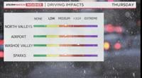
Travel will be challenging in the Sierra as well, including I-80 east and west, Highway 50, and Carson Pass. Visibility will be poor and another 1-2 feet will fall. I-580 south towards Carson City will be challenging as well due to poor visibility, moderate snow, and slick roads.

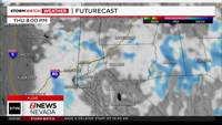
The heaviest snow will fall in the late morning early afternoon hours, becoming spotty as the day goes on. The snow bands that pop up in the afternoon do have the capacity to produce a lot of snow within a short time, as they will be convective in nature. Which means, while the snow won't be as widespread Thursday afternoon, the snow that does develop will pile up quickly.
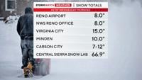
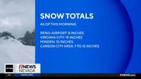
Overall, snowfall rates will be less than an inch per hour in the valley, but could top that in places like Galena, Washoe Valley, Minden, Carson City, and southeast Reno. Even Fallon, Dayton, and Yerington could see some snow today.

After a fairly mild winter and a cold air mass moving over the lake, lake enhanced snow cannot be ruled out. The flow will also come out of the east in advance of the low, allowing for uplift along Mt. Rose Highway and Highway 50 at Spooner. The flow is coming out of the southwest on the western side of the low moving over Tahoe and causing lake enhanced snow. As the low moves southeast, the main snow bands will move southeast as well.
A few spotty snow showers will come in from the north as the low travels southeast this evening, impacting places like Pyramid Lake and Fernley, where some localized lake effect snow can't be rule out either. By and large though, areas north of I-80 will see less snow than neighborhoods south of I-80.