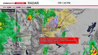
We live in a unique area and the mountains are big reason for that. For much of the country, meteorologists look at the surface just as much as they look at the upper levels of the atmosphere. In a place that is higher up in elevation, 850mb is closer to the surface than say 925mb or 1000. Fronts all have a hard time staying together as they move east over the Sierra. Especially warm fronts. For the rest of the country, certain wind directions are indicative of where you are in correlation to a front, but in an area where wind directions change so easily and vary within a short distance because of terrain, this can be challenging for a meteorologist to figure out. For example, when I worked in South Dakota, a westerly wind meant the storm had more than likely passed. Not the case in Reno. Here we usually see a southwesterly wind in front of a system because of elevation impacts and pressure changes. When I’m looking for a cold front I usually look at the 700mb or 850mb level. In a region that has a higher elevation, a higher atmospheric level shows where the cold air and warm air is more easily. The image below shows cooler air to the north in blue.


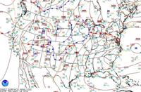
In weather school I learned how to spot cold fronts and warm fronts. Just like clockwork. A cold front to the west and a warm front to the northeast of the low. Storms usually occur in front of the cold front in what’s called the warm sector. Southeasterly or southerly flow usually means you’re in the warm sector where it can be warm and humid. Especially if you live in the southeast. The image below shows a mid-latitude cyclone in the Midwest with a cold front and a warm front. The symbols makes it easier to pick out. Notice how the flow comes out of the south in front of the cold front and northwest behind it. Just like clockwork.

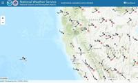
The image below is from our area. We have a system moving through, but our winds are going in a variety of directions. Wind is related to pressure, and elevation influences pressure and temperature greatly. Our flow does tend to come out of the north behind a front though. Looking ahead, Friday does appear to be a nice day with temperatures in the upper 60’s/low 70’s and partly cloudy skies. Another system moves in by Sunday. Have a great weekend.