Update (11/22, 2:10 p.m.):
Chain controls are up along I-80 over Donner Summit, per Caltrans.
Chains are required on all vehicles except four-wheel/all-wheel drive vehicles with snow tires; eastbound from Kingvale to Truckee, westbound Truckee to Rainbow.
ORIGINAL STORY:

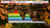
Another round of active weather moves through the Sierra and Truckee Meadows today. A High Wind Warning is posted for the Sierra front, including Reno, Sparks, and Carson City through 1am for wind gusts up to 65mph and 80mph in wind prone areas. The worst of the wind will be between 5-10pm Friday evening. The wind will be strong enough to cancel flights, and perhaps knock down some tree branches. Make sure all of your decorations are tied down or inside, so you don’t lose them.
Along with the High Wind Warning, there is also a Red Flag Warning posted for the Southern Sierra Front and western Basin and Range through 7pm Friday. This includes northern Mono, southern Lyon, western Mineral, and Churchill counties.

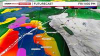
Not only will it be windy today, but there is also a good chance for spill over in the valley by 7pm. The rain will start out light in the late afternoon, before turning heavy at 9pm. There could be some ponding on the roadways as a result. Oftentimes, the wind stops as the rain starts, but we could have both at once this time around.

After a brief break in the snow at Donner Friday morning, more snow will start to fall at Donner by 11am Friday and persist through Saturday morning. A Winter storm Warning is up for the Tahoe basin beginning at 10am Friday and going through 10pm Saturday night. A couple more feet of heavy wet snow could fall in the high Sierra on the western side of Tahoe over the next 24 hours.
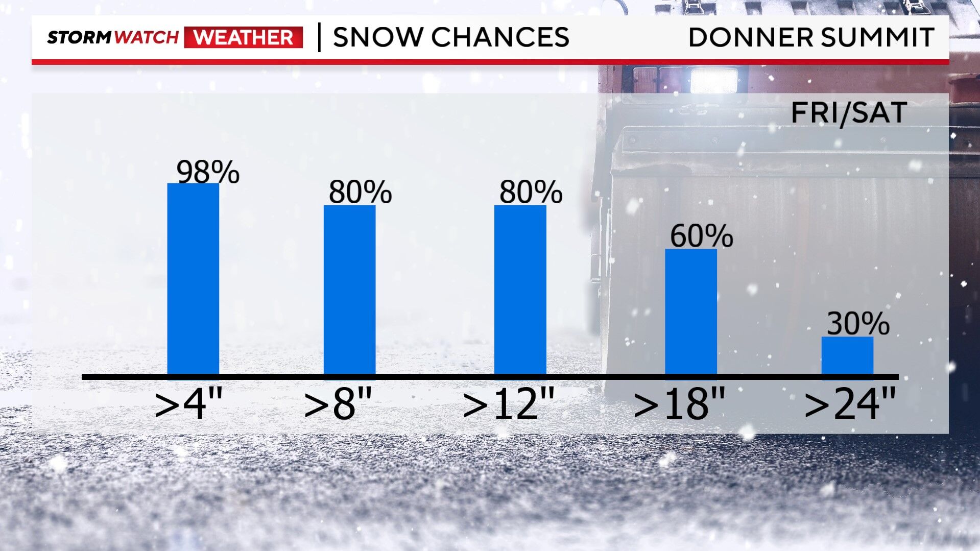

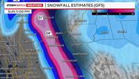
A second, colder, round will move through the mountains late Sunday through Tuesday. This round could produce another one to two feet of snow as well. If you plan on traveling this weekend, try to get over the hill between 2pm Saturday and 12pm Sunday. It won’t be perfect then, but certainly better than Friday night.

The snow level drops to lake level Saturday morning, with most of the Truckee Meadows only seeing rain Friday night, but areas at or above 5500’ could see a rain/snow mix by 5am Saturday morning.
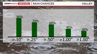
Rain totals will range from a quarter of an inch to an inch by Saturday in the valley. The Tahoe area could see over an inch of rain before it starts to snow. Rain and snow will continue to fall in northeast California, where a Flood Advisory is posted for parts of Lassen, Plumas, and Sierra Counties along the Susan River, for minor flooding.

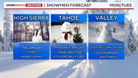
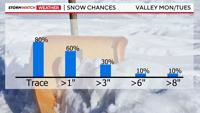
A third and final round of wintery weather moves in late Sunday through Tuesday. This will be the coldest round out of all of them, allowing the snow to pile up quickly. This means the Sierra could see another couple feet of snow above 7000’ in elevation. It will be more scattered in the valley on Monday and Tuesday, with a mix of both rain and snow. Snow totals will be light in the valley, with nothing more than a couple inches.
There will also be more precipitation on the west side of town than say Sparks. The bulk of the wintry weather will be on Tuesday.

Wednesday will be a better travel day, as well as Thanksgiving day itself, but if you must travel this weekend, late Saturday through the first half of Sunday will be okay. Not perfect but better than Friday night or late Sunday into Monday/Tuesday.
Stay tuned for more weather updates as the storm continues to evolve.